About Doppler storm radar - eMap HDF
eMap HDF is a high-resolution predictive NOAA Doppler storm radar with a weather map. The weather app has the next layers provided by the National Weather Service (NWS) & NOAA: - Snow and rain radar - Severe
eMap HDF is a high-resolution predictive
NOAA Doppler storm radar with a weather map.
The weather app has the next layers provided by the
National Weather Service (NWS) & NOAA:
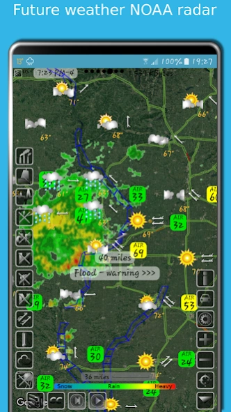
- Snow and rain radar
- Severe weather alerts, tornado tracker, heavy rain and wind alerts
- Lightning strike map
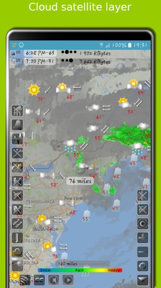
- Cloud satellite layer
Worldwide layers:
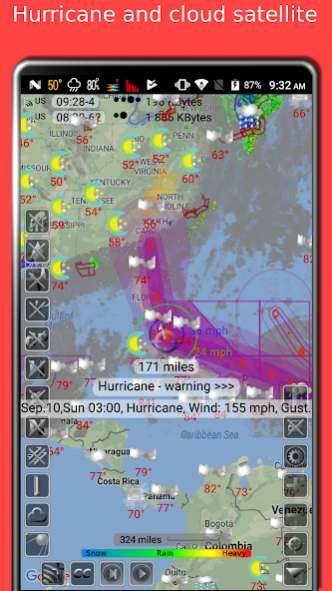
- Typhoon (tropical storm, cyclone) and hurricane tracker provided by GDACS
- Accurate weather forecast for 10 days
- Hourly weather forecast for 24 hours
- Air quality and air pollution
- Earthquake map
- Temperature map
- Sea temperature based on measurements from buoys and satellites
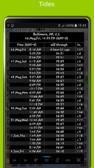
- Tide charts
- Local time in each city
- Number of residents in cities
- Road traffic
- Buoys
- Dew point
- Humidity
- Wind map
The storm radar app calculates a
one-hour prediction of rain and snow in five-minute frames. NOAA radar has a six-hour weather radar history.
Tide times are for over
10,000 tidal stations in the US, UK, Canada, etc. with forecasts for several months. The app follows the current location and shows the tides near me.
The earthquake app includes earthquakes
filtered by magnitude and depth. Earthquake tracker data is provided by the USGS.
The distance measurement tool shows the
distance between two points in miles and kilometres.
The air quality app includes concentrations of ozone (O3), fine (PM25) and coarse (PM10), particulate matter, dioxide (NO2) and nitrogen oxide (NO), carbon monoxide (CO), etc. from various sources:
AirNow , Copernicus, ECMWF, etc.
With the Doppler radar app, you can long-click on any location on the map and see the weather at that location with the
archive for the last few years . The archive includes sea and air temperature, precipitation and cloud cover. Travel weather helps you choose the right time and place for your upcoming trip and compare temperatures and precipitation between this year and past years.
If you click on the "CC" button and toggle to "10" or "24", you can view a 10-day or 24-hour forecast
directly on the map.
eMap HDF shows
road traffic . The forecast includes not only temperature and precipitation, but also humidity, wind speed and direction, dew point, visibility on the roads feels like temperature.
As the data published in eMap HDF is not subject to use on the voyage, please do not use it for navigation.
Previous Versions
Here you can find the changelog of Doppler storm radar - eMap HDF since it was posted on our website on 2016-09-22 08:59:26.
The latest version is 2.3.2 and it was updated on 2024-04-23 10:54:23. See below the changes in each version.
Doppler storm radar - eMap HDF version 2.3.2
Updated At: 2023-12-23
Changes: Search location by name
Some errors were fixed and the user interface was improved
Doppler storm radar - eMap HDF version 2.2.9
Updated At: 2021-10-10
Changes: Added tide charts and tide tables
Added seven years weather archive
Added day and night map theme
Added navigation bar for radar and cloud satellite layers
Added air quality graph for last 24 hours
Some errors were fixed and the user interface was improved
Doppler storm radar - eMap HDF version
Updated At: 2020-06-08
Changes: Improved user interface, security, privacy, stability
More details added to the air quality layer
Doppler storm radar - eMap HDF version
Updated At: 2020-02-01
Changes: Earthquake list window bug fixed
Doppler storm radar - eMap HDF version
Updated At: 2020-01-15
Changes: improved app performance
Doppler storm radar - eMap HDF version
Updated At: 2019-10-17
Changes: Added lightning strikes layer for South and North America
Added option to display only ground based or only cloud satellite data for air quality
Doppler storm radar - eMap HDF version Varies with device
Updated At: 2018-11-08
Changes: New design for earthquakes and hurricanes.
Some errors were fixed.
Doppler storm radar - eMap HDF version 1.1.0
Updated At: 2015-09-24
Changes: - tide predictions,- hurricane (tropical storm) tracking,- follow by location,- eWeather HD integration,- options for vibration, color, transparency for the satellite layer,- more visible buttons,- added scale of a map,- improved app work on large map scales
Disclaimer
Official Google Play Link
We do not host Doppler storm radar - eMap HDF on our servers. We did not scan it for viruses, adware, spyware or other type of malware. This app is hosted by Google and passed their terms and conditions to be listed there. We recommend caution when installing it.
The Google Play link for Doppler storm radar - eMap HDF is provided to you by apps112.com without any warranties, representations or guarantees of any kind, so access it at your own risk.
If you have questions regarding this particular app contact the publisher directly. For questions about the functionalities of apps112.com contact us.